
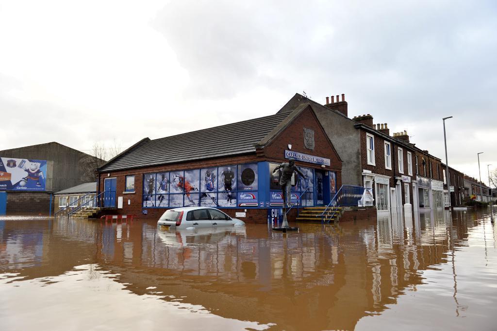
New flood defences designed to protect Carlisle from another Storm Desmond-type disaster will not achieve their goal, say campaigners.
The devastating floods of December 2015 - caused by unprecedented rainfall - left nearly 2,000 homes across the city flooded, with homes in the Warwick Road area particularly badly hit. Blue ribbons can still be seen, tied around trees and lampposts to mark the water height.
The Environment Agency has now unveiled its proposals for new defences to prevent a repeat of the disaster.
Costing £25m, the Carlisle Flood Alleviation Scheme involves creating a ring of raised embankments and anti-flood walls, with higher defence barriers in key locations such as between the river Petteril and Warwick Road and in Melbourne Park, where flood defences would be raised by up to half a metre.
But Carlisle Flood Action Group (CFLAG) has questioned whether the scheme’s Phase 1 - costing £6.6m - could adequately protect the east side of Carlisle from a future Storm Desmond.
In a report - written for the city council’s development control committee as it considers the plans next week - CFLAG raises concerns about the 80-year-old Botcherby Bridge, which experts say acted as a dam in 2015, forcing fast-moving flood water from the river Petteril into residential areas.
One campaigner fears there could be a fatality if the bridge is not improved.
The Environment Agency has rejected the criticism, insisting its scheme will protect east Carlisle and the bridge will be safe.
“Botcherby Bridge was not designed as a flood defence,” says the CLFAG report. “...currently great faith is being placed upon the strength of the existing bridge parapet as a flood defence.
“If this remains the case, the applicant [the Environment Agency] should prove that the current structure can resist the river energy at a [Storm] Desmond peak level and be made to improve early conveyance of the [river] Petteril peak.”
The report says the proposed defences would not
contain the amount of water that was spewed onto Warwick Road in 2015. It suggests higher defences and building up the bridge parapet by two thirds of a metre.
The document adds: “Works following the 2005 [Carlisle] flood made the flood of 2015 deeper than before as defences were overtopped and outflanked and water corralled into an informal reservoir within the residential area.
“CFLAG’s work, in checking the current scheme, shows that this may well occur again in another Storm Desmond situation even if to a lesser degree. All that can be said is that the failure of defences will occur later in the event than they did on December 5, 2005 and so for a shorter duration....
“Significant extra work is required to achieve the applicant’s stated goal and the public should be aware that the proposal does not, in CLFAG’s view, proved the level of protection claimed.”
CFLAG’s member Richard Milne added: “The whole point is they are raising the flood defences and they are going to use the Botcherby Bridge parapet as part of the flood defences. But if that parapet fails there’s the potential for people to drown...Two people drowned in 2005 within 100 yards of Botcherby Bridge.”
John Kelsall, who is also part of CFLAG, does not believe the proposals are sufficient to prevent flooding on the same level as Storm Desmond.
Warwick Road resident Neil Kilgour said: “As the houses along my side of Warwick road were flooded from Tesco, I welcome the plans to do the work in this area.”
Phase 1 of the scheme include:
* Raising the wall between Warwick Road and Wallace Gardens
* Flattening and smoothing the underside of Botcherby Bridge to reduce water turbulence and friction;
* Building up the embankment between Wallace Gardens and Jesmond Street
* Reinstating the 250m riverside footpath along the embankment between Wallace Gardens and Riverside Way
* Install new 250m earth embankment extending south from existing embankment to high ground adjacent to Adelaide Street
* Installing a cut-off trench below ground along the wet side of the embankment and a drain along the dry side
* Building up the embankment between Warwick Road and Falcon Meadows
* And reconstructing an earth embankment near Falcon Mews.
Stewart Mounsey, the Environment Agency’s flood and coastal risk manager, welcomed the CFLAG comments.
“Flood risk has been a feature in the lives of people in Carlisle for many years and the £60m flood risk management scheme built by the Environment Agency following the floods of 2005 has successfully protected nearly 3000 properties from flooding on numerous occasions,” he said.
“It has also given the city increased warning times, which allows families and businesses to react to rising rivers levels. However with climate change more frequent and extreme events are likely in the future and we need to do more.
“The new proposed scheme is designed to deliver Storm Desmond level of protection.
“Our work to date has indicated that the most effective way to manage flood risk in the city is to raise existing walls and embankments where necessary and improve the movement of water through bridges; where it is a viable option. Our proposals for Botcherby Bridge will include: works to make gravel management more straight forward; improvements to the bridge structure and upstream river channel as it approaches the bridge.
“We will build a raised earth embankment upstream of the bridge to allow water levels to rise and push a greater amount of water under the bridge thus reducing peak water levels and the likelihood of the upstream embankment being overtopped by the river.”
He said the scheme was designed in accordance with all relevant standards and codes of practice.
“Our engineers have designed measures to protect Botcherby Bridge from the additional flood loads. Cumbria County Council Highways have been consulted on these measures and will be responsible for formally approving the principles and design methods to assure that these are fully compliant.
“The Environment Agency’s planning application will invest £6.6m in Carlisle. With that £6.6m we will enhance the scheme we built in 2005 giving even greater flood protection to over 1200 homes and 107 other properties.”
GFLAG’s calculations did not account for the increased river flow rate past Botcherby Bridge created by raising the defences within Melbourne Park, says the Agency.


Comments: Our rules
We want our comments to be a lively and valuable part of our community - a place where readers can debate and engage with the most important local issues. The ability to comment on our stories is a privilege, not a right, however, and that privilege may be withdrawn if it is abused or misused.
Please report any comments that break our rules.
Read the rules here